

Catoctin Formation: A catoctin is defined as “a residual hill or ridge that rises above a peneplain and preserves on its summit a remnant of an older peneplain,” where peneplain is “an erosion area of considerable area and slight relief.” [1] It is derived from Catoctin Mountain in north-central Maryland where the Catoctin Formation was first noted as consisting of a geologic plain rising above a plain. Some sources contend that a tribe of Native Americans called Kittocton were resident in the general area and if that is the case, it is almost certain that Catoctin is a toponym. [2] However, the existence of a tribe named Kittocton is probably specious as the tribe is not listed by the National Geographic Society. [3] Many geographical names came into common parlance without any records―ancient wooded hill, land of many deer and speckled mountain have also been proffered as the meaning of Catoctin in one of now lost Native American languages.
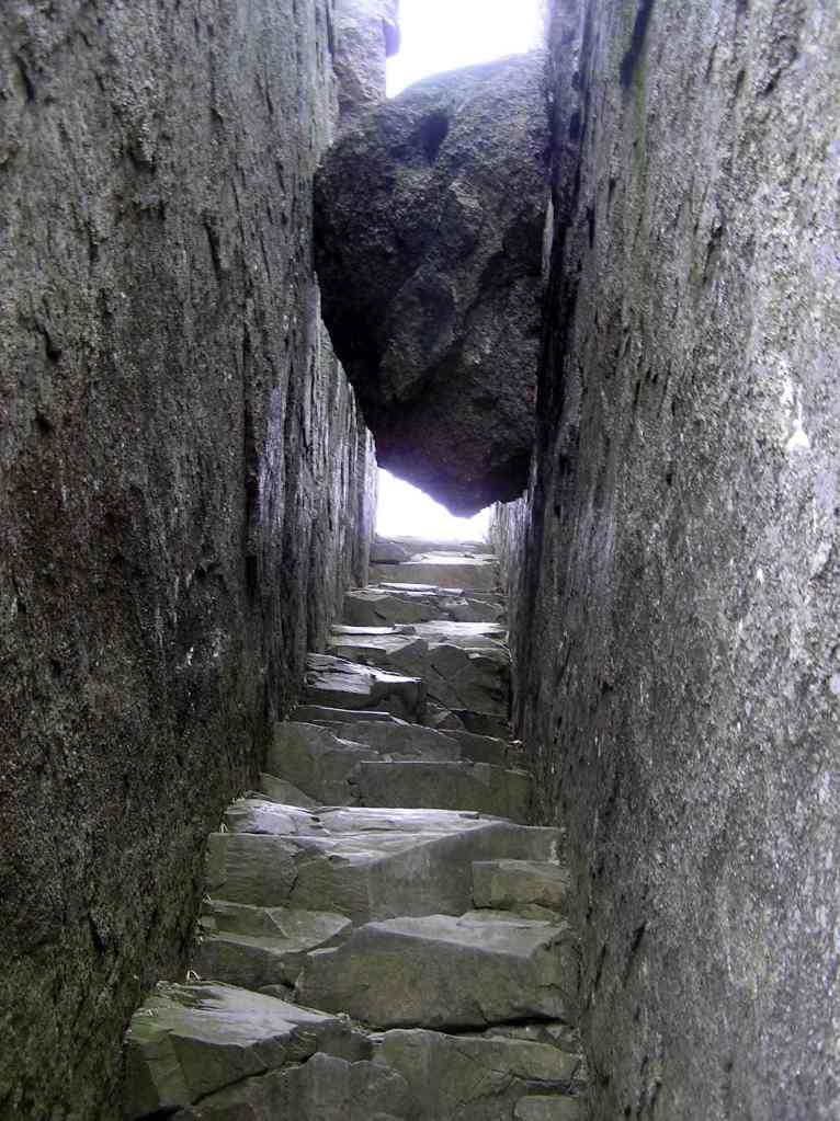
Potpourri: The Catoctin Formation is the most recognizable geological feature of the Blue Ridge Province of the Appalachian Mountains. Its origin as lava that flowed out of fissures in the earth’s crust is evident in the sequential cascades that solidified as they spread over the pre-Cambrian landscape about 600 million years ago (mya). Even though it was named for Catoctin Mountain, where it can only be seen in a relatively few and out of the way places, it is the capstone rock assemblage in Shenandoah National Park. The Marshall Mountains dominate the northern section of the park, benches of lava flowing outward to form the roadbed for Skyline Drive. White Oak Canyon, a cynosure of the central section follows the circuitous lava flow path. The Appalachian Mountains are over a billion years old. In contrast, the 60-million-year-old Rocky Mountains and even younger Himalayas are relative newcomers to terra firma. The Catoctin Formation is the keystone that connects the arc of the ancient past to the ever-evolving present. [4] How could magma from earth’s liquid mantle flow through and then out over the crust in a place that is now as placid and peaceful as a national park in western Virginia?
Plate tectonics emerged as a coherent and scientifically supported theory of geology in the middle of the last century. It was first postulated by the German meteorologist Alfred Wegener in 1915 based on the conformity of the contours of the western coastline of Africa and the eastern coastline of South America. Supporting observations of geologic and fossil similarities that straddled not only South America and Africa, but also Australia and India could only be explained if these areas had at one point been connected in a single land mass, eventually named Gondwanaland for a region in India. The idea that massive continent-sized chunks could somehow move around, floating on top of a pool of molten rock agitated by planetary rotation and lunar gravity, and plow through oceanic crust like an ice breaker seemed too fanciful to many geologists until the middle of the century when further research revealed a viable mechanism. Sea floor spreading was confirmed by the observance of magnetic field shifts in solidifying magma flows in the mid-ocean ridges to provide a source of new crust. That earthquakes recurred in known prone zones led to the notion that plate movement was involved. The term subduction was given to the sliding of great arcs of oceanic crust under adjacent and less dense regions of crust to be remelted as magma in the mantle. With a supply of new magma emerging from the ridges and a recycling facility for old magma in subduction, there was no need to plow through anything. [5] So what has all this got to do with the Catoctin Formation?
The tectonic plates, many with lower density sections that are the land mass continents contained within their boundaries, have been floating around driven by the chaotic forces of physics by the liquid mantle for most of Earth’s 4.5-billion-year history. When two plates with the less dense continental crust float into each other, subduction is not an option and a headlong crash results. When an irresistible force meets an immovable object, something has to give and the only option is skyward. The result is an orogeny, from the Greek oros, meaning mountain. The mountain building orogeny that created the original Appalachian Mountains about 1.2 billion years ago is named Grenville for a small town in Quebec on the Canadian Shield central core of the North American plate. Wegener’s preliminary hypothesis that there was a contiguous area he called Gondwanaland was later expanded to include a second northern land mass named Laurasia that joined to form the supercontinent Pangaea (Greek for all earth) about 300 mya. Over the last several decades, additional geological analysis of bedrock on a global scale has concluded that the movement of plates results in the reassembly of at least 75 percent of all the jigsaw puzzle of landforms into a supercontinent roughly every 750 million years. Pangaea was proceeded by Rodinia, a name derived from the Russian word rodit meaning to give birth as it was at first thought that Rodinia was the original supercontinent that gave birth to all others. Further research has posited an additional supercontinent named Columbia that precedes Rodinia with evidence of additional combinations that extend as far back as the Proterozoic Eon that started 2.5 billion years ago. [6]
The bedrock of the Appalachian Mountains was then the result of the collision of the land mass containing North America named Laurentia with the land mass containing northwestern Eurasia named Baltica that gave rise to what was to become Laurasia (North America and Eurasia) about 1.2 billion years ago. When Rodinia started to break apart about 700 mya, fissures opened, allowing magma in the form of lava to flow upward out of the mantle, through the bedrock of the Grenville orogeny, and spread out over its surface. This is the fons et origio of the Catoctin Formation. Continued expansion in a manner similar to the opening of the eponymous Atlantic Ocean in the present geologic age resulted in its precursor named Iapetus, the father of Atlas in Greek Mythology. Initially, the cooled magma was covered by rough gravel at the shallow waters edge as the mountains were worn away by erosion. As the ocean expanded, the now submerged Appalachian bedrock with its lava coating became covered by smaller sized particles, and eventually the fine silted sand of mid ocean. The gradation of sediments of stone to pebble to sand on top of the Catoctin Formation is evident in the present day Weverton, Harper’s, and Antietam formations that make up the Chilhowee Group. [7] Iapetus stopped opening and began to close about 400 mya, creating Pangaea from Laurasia and Gondwanaland with a series of three orogenies named Taconic, Acadian, and finally Alleghany as the various plates collided from north to south. The resultant Appalachian Mountains were probably as high or higher than the Rockies at their peak uplift. Pangaea’s disassembly started near the end of the Mesozoic Era about 65 mya and is still in progress, the once buried lava rocks of the Catoctin Formation now in full view after millennia of erosion of the once majestic mountains to create the coastal plane. [8]
Geology as the science dealing with the physical nature and history of the earth has evolved extensively through the ages; even the rather obvious origins of lava have been misunderstood. While the Greeks and Romans appreciated the nature of lava and eruptions (the burial of Pompeii by the eruption of Vesuvius in 79 CE could hardly have been misinterpreted), the ensuing Dark Ages of biblical doctrine stifled the study of nature. According to Archbishop James Ussher of Ireland, the earth was created on Sunday, 23 October, 4004 years Before Christ and Noah’s flood was responsible for all current landforms. Even when science rebounded after the Renaissance, geology was especially difficult since it is mostly out of sight in tangled knots of rocky confusion. The noted German geologist Abraham Werner conceived that a universal ocean originally covered the earth and that all rock precipitated from it, dismissing the volcanic origins of lava altogether. His adherents, which included most geologists in the eighteenth century, were called Neptunists for the Roman God of the Oceans Neptune. The Vulcanists named for the Roman god of fire and the hearth, restored lava to its true provenance as magma emerging from fiery mantle. The word lava came into wide use in the 17th century from the Italian dialect around Naples, Italy (near Vesuvius) and meant something like falling― presumably from Vulcan’s home which had become a volcano. Lava, in current parlance that reflects decades of study, comes in three basic forms: A’a for rough, fragmented blocks; Pahoehoe for smooth, undulating flows; Pillow for lava that emerges under water. A’a and pahoehoe are of Hawaiian origin due to the importance of the perennial lava flows that were key to early studies in volcanology. The lava of the Catoctin Formation is primarily dry, flowing, pahoehoe.
The primary constituent of the Catoctin Formation is basalt (from the Greek basanites, a type of slate used to test gold from basanos meaning test). Basalt is an igneous (ignis is Latin for fire) rock, the generic name for any rock created directly from magma, the liquid rock of the mantle. Because of the low silica content, basalt has a low viscosity, so that the lava flow can move relatively quickly and travel as far as 20 kilometers from the source, which can be either a single vent or a long fissure. Basalt is erupted at temperatures that range from about 2000 to 2100 °F, to become either a’a or pahoehoe depending on temperature and topography. Basalt is the most abundant igneous rock in the earth’s crust, comprising almost all of the ocean floor. A rock is defined by the combination of minerals that it contains. A mineral is “a natural substance, generally inorganic, with a characteristic internal arrangement of atoms and a chemical composition and physical properties that are either fixed or that vary within a definite range.” [9] The primary minerals that make up the rock basalt are pyroxene and feldspar.
Pyroxene is from the Greek pyr and xeno meaning “alien to fire.” The pyroxene of Catoctin Formation basalt is a complex of different minerals that are silicates of magnesium and calcium and which include iron and manganese. The general formula is X(Si,Al)2O6 where X can be calcium, sodium, iron, or magnesium. Magma that contains significant amounts of magnesium (Mg) and iron (Fe) is called mafic as an acronym for these elements. The other major component of magma consists primarily of feldspar and silica; it is called felsic according to the same logic. Feldspar, the other major constituent of Catoctin Formation basalt, is a complex of aluminum silicate minerals, i.e. containing aluminum and silica, in combined with potassium (KAlSi3O8), sodium (NaAlSi3O8) or calcium (CaAlSi2O8). Feldspar is derived from feldspat, German for “field flake” referring to common rocks typically strewn about an open area that could readily be cleaved into flakes. Feldspar comprises over fifty percent of the earth’s crust. The similarity between basalt and feldspar in terms of elemental composition is due to the dominance of oxygen in chemical combinations. The earth’s crust is about 50 percent oxygen combined with 30 percent silicon, 8 percent aluminum with iron, calcium, sodium, potassium and magnesium making up most of the balance at 2 to 5 percent each. [10]
The basaltic lava flows that first emerged from the mantle during the breakup of Rodinia have been subject to 600 million years of change. This included some millions of years under the Iapetus Sea and the crushing pressures of the assemblage of Pangea. The effects of the pressures and temperatures of deep depths and orogenies on existing rocks changes their shape, structure and properties. The name for the resultant rocks is metamorphic, literally changed body. To provide an overarching order to the otherwise intricate complexities of the mineral combinations of individual rocks, they are subdivided into three general types. Igneous rocks of the magma were first, solidifying in the first days of the nascent Earth’s cooling. Water evaporated from the primordial oceans precipitated as rain over lava lands, causing the erosion to transport grain by grain into the ocean to form sediments that gradually sank under their own weight to form sedimentary rocks. As the physics of balancing forces formed separated plates that drifted in their own magma ocean, the resulting colossal forces changed or metamorphosed the igneous and sedimentary rocks. Sedimentary shale became slate and igneous basalt became metabasalt. The Catoctin Formation that remains is the result of an unimaginable journey that took it from the peak of the tallest mountains to the deep sea and back again. While it still retains its basic lava-like appearance in places, it is comingled with many other rock types with their own histories. It has equally been subjected to differing environs that changed its core composition.
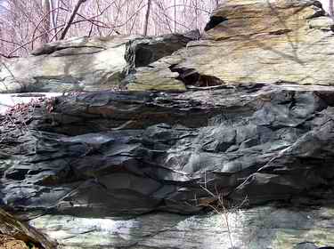
The Catoctin Formation has the colloquial name greenstone due to the gray-green coloration of many outcroppings, a result of its metamorphic journey. The Catoctin basalt is comprised of phenocrysts (large crystals) of plagioclase feldspar named albite in a fine-grained matrix of the minerals chlorite, magnetite, actinolite, pyroxene and epidote. Epidote is a structurally complex mineral of calcium, aluminum, iron and silicon [Ca2 (Al, Fe) 3(SiO4)3(OH)] that has a green color described as pistachio. It is this mineral that, when present, gives the Catoctin Formation a distinctive greenish hue. The sequential lava flows over an extended period are reflected in the diversity of the Catoctin Formation. The boundaries between the lava flows are marked by breccias, metatuffs, and metasandstone. Breccia is a rock comprised of smaller rock fragments cemented together by sand, clay and/or lime. These rocks identify areas where a crust formed on a lava flow that was disrupted by subsequent flows. A tuff is a porous rock created by a consolidation of volcanic ash. The metabolized tuffs, or metatuffs, are attributed to a rapidly moving cloud of molten ash. The metabolized sandstones, or metasandstones, mark the boundary between one lava flow, a period of erosion and sedimentation, and a second lava flow. [11]
References:
1. Webster’s Third New International Dictionary of the English Language, C. G. Merriam Co. Encyclopedia Brittanica, Inc, Chicago, 1971 p 354, 1669.
2. http://www.npshistory.com/publications/cato/index.htm
3. “Indians of North America” National Geographic, Volume 142, Number 6, December 1972
4.Gathright, T., Geology of the Shenandoah National Park, Virginia Department of Mineral Resources Bulletin 86, Charlottesville, Virginia, 1976, pp 19-25.
5. Cazeau, C., Hatcher, R., and Siemankowski, F. Physical Geology Harper and Row Publishers, New York, 1976, pp 374-393.
6. Meert, J. “What’s in a name? The Columbia (Paleopangaea/Nuna) supercontinent”. Gondwana Research. 14 December 2011, Volume 21 Number 4 pp 987–993. https://www.gondwanaresearch.com/hp/name.pdf
7. James Madison University Geology Notes – https://csmgeo.csm.jmu.edu/geollab/vageol/
8. Schnidt, M. Maryland’s Geology, Shiffer Publishing, Arglen, Pennsylvania, 2010, pp 88-112.
9. Dietrich, R. Geology and Virginia, The University Press of Virginia, Charlottesville, Virginia, 1970, p 4.
10. Cazeau et al op cit. 11. USGS Geological Survey Bulletin 1265 “Ancient Lavas in Shenandoah National Park Near Luray, Virginia” https://www.nps.gov/parkhistory/online_books/geology/publications/bul/1265/sec2.htm
