
Fall Line – A fall line is defined as a line of numerous waterfalls such as at the edge of a plateau where water flows over hard, erosion-resistant rocks onto a weaker substrate that washes away to create a vertical drop. Also called a fall zone where it extends over a large geographic area.
Potpourri: Fall line waterfalls occur globally wherever the edge of a land continental plate abuts the coastal plain formed on its perimeter from the sediments deposited from upland erosion. Examples include Africa, Brazilian South America. Western Australia, and the Indian subcontinent of Asia where the Jog Falls plunges 830 feet. The world’s most prominent and prevalent fall line is where the crystalline Appalachian Mountains meet the sedimentary coastal areas of eastern North America. From north to south, the major rivers that cross the fall line are the Delaware, Schuylkill, Patapsco, Potomac, James, and Savannah originating to the west and north and flowing southeastward through the Appalachian Piedmont Province toward the Coastal Plain abutting the Atlantic Ocean. The Susquehanna River is not included because it is older than the mountains through which it passes. Because falling water junctures block river traffic upstream from moving downstream and vice versa, they are a natural location for entrepôts of goods passing from the coast to the hinterland to be traded for produce and raw materials. The rushing waters became the motive force for the mills and factories that formed the backbone of the nineteenth century Industrial Revolution in the United States. Ultimately, the cities Trenton, Philadelphia, Baltimore, Washington D. C., Richmond, and Augusta arose along the Atlantic Seaboard Fall Line that are connected by US 1, the original north south connecting route now paralleled by I-95. There are also many smaller rivers flowing generally eastward with towns of varying size at their fall line such as Wilmington, Delaware on the Brandywine River and Fayetteville, North Carolina on the Cape Fear River. [1]
The geography of the fall line is complicated. It has a north-south range of almost a thousand miles of locally diverse terrain encompassing an array of canals, dams, bridges, and harbors engineered over the centuries to move around and over the waterfalls. The colonial settlements of the coastal plain reaching ever westward to penetrate into the upland regions of the Appalachian Piedmont Province had a major impact on its waterways, notably the Patapsco and the Potomac River basins. Two years after the Catholic King Charles I signed a charter for the heirs of Lord Baltimore to establish a colony in honor of Queen Henrietta Maria, the Ark and the Dove anchored off an island in the Potomac to settle at a spot soon to be named St. Mary’s. The success of tobacco plantations over the course of the next fifty years encouraged population growth and investors with venture capital such as Charles Carroll, a physician from Annapolis. In August 1729, the Maryland assembly passed an act providing for a town named Baltimore on land owned by Carroll at the mouth of the Patapsco. The location along the western shore of the Chesapeake Bay was the terminus of the falling waters of a Patapsco River tributary that ended in a sheltered cove ideal for a harbor. With a flour mill for grain brought downriver from the west and an iron mill to take advantage of the iron deposits and the abundant forests for charcoal fuel, Baltimore became established as a fall line city, shipping almost 2,000 tons of pig iron to England between 1734 and 1737. At about the same time, a village in Prince George’s County along the Potomac River became prominent as a mercantile location near what were called the Potomac Rapids. It was eventually named Georgetown. [2,3]
The Potomac River proved more consequential than the Patapsco due to its extensive drainage, emanating from the heart of the Appalachian Plateau in what is now West Virginia. The importance of linking the eastern seaboard with the western hinterlands was one of George Washington’s first and most enduring predilections. Having surveyed the extensive holdings of Lord Fairfax in western Virginia and operated on the frontier during the French and Indian War, Washington gained an appreciation for the geographic constraints of the colony. Emerging victorious and idolized for his pivotal role in the Revolutionary War, he returned directly to his grand design, setting off on 1 September 1784 to take stock of the western lands [4]. Based on his journey, he wrote a letter to Governor Harrison of Virginia that it was necessary “to prevent the trade of the western territory from settling into the hands of the Spaniards or the British” to “extend the navigation of the eastern waters; communicate them as near as possible with those which run westward.” The first challenge was to enlist the support of the legislatures of both Maryland and Virginia to overcome the jealousies and rivalries between the merchants of Baltimore and Georgetown. Appointed as chairman of a commission to investigate the feasibility of making the Potomac River navigable by the Maryland General Assembly in 1784, Washington chaired a joint conference with Virginia that issued a resolution in favor of “removing the obstructions in the River Potomac, and the making the same capable of navigation from tide-water as far up the north branch of the said river as may be convenient and practicable.” The Patowmack Company was organized in 1785 to get around the fall line. George Washington was its president until 1792 when he resigned to start a new job with greater responsibilities. [5]

There were five sections of the Potomac River that were impassable to watercraft due to rapid currents, shallow depths, and waterfalls. Great Falls, the only true waterfall and Little Falls, an area of rapids just upstream of Georgetown, were the only two that would require a series of locks and canal segments to bypass the river altogether. The other three, Seneca Falls on the Virginia side of the Maryland creek of the same name and House and Shenandoah Falls near Harper’s Ferry would require only dredging of canal passages for deep draft boat access. Even though the Patowmack charter provided “liberal wages” for “any number not exceeding one hundred good hands” each provided with one pound of salt pork and three jills of rum daily, laborers were hard to find. The task of building multiple canals in five different locations proved to be daunting, with progress plagued by periodic flooding, delays in construction material supplies, and poor management. The five locks for the 80 feet of vertical elevation change for the canal passage around Great Falls were not completed until 1802, seventeen years after the first work started and fourteen years later than predicted at the outset. The Patowmack canal system boats and barges carried thousands of barrels of flour and whiskey and bushels of corn and wheat between Georgetown and Cumberland until 1828, when bankruptcy forced divestiture.[6] Its successor as fall line bypass was the Chesapeake and Ohio Canal, initiated on the 4th of July 1828 with President John Quincy Adams presiding at the ground-breaking ceremonies. On that same day in the Patapsco basin near Baltimore, the first rails of the Baltimore and Ohio Railroad were laid with Charles Carroll presiding as the only surviving signer of the Declaration of Independence. The C&O Canal would eventually meet the same fate as the Patowmack, becoming obsolescent and financially unsound as the railroads that could move heavy loads across the fall line without the need for waterborne carriage offered a cheaper alternative.
The geology of the fall line is both complicated and simple. Its inception as the edge of a tectonic plate that was once part of a larger continuum, in this case Pangaea, is simple. The complex conglomeration of both igneous and sedimentary rocks subject to the metamorphism of crushing plate forces is complicated. Alfred Wegener is the Charles Darwin of geology, having first explained the jigsaw puzzle fit of South America into the indented west African coast with the theory of continental drift in 1912. Widely dismissed by most geologists at the time, the idea gained traction in the 1960’s when the periodic (about once every 500,000 years) magnetic reversal of the north and south poles were detectable in the bedrock of the Atlantic Ocean, which would be the case if the sea floor was spreading. Subsequent geologic expeditions confirmed similar rock types and ages leading to the notion that the Wegener’s drifting continents were actually plates which at one point had been conjoined as the single global continent Pangaea that formed in the late Paleozoic Era about 300 million years ago. With a motive force thought to be the convective upwelling currents of the molten magma in which the plates “float,” Pangaea broke up between 200 and 65 million years ago. The eastern edge of the North American plate that had been abutted by the African plate to the south and the Eurasian plate to the north became over eons of time the fall line, its erosive rivers filling the coastal plane with the clastic sediment along its edge [7] Tectonic plate direction and drift rate of about 1.5 inches a year will move them back together in what has been called Pangaea Proxima with Eurasia to the east, North America to the west and Africa above South America in the middle some 250 million years in the future inhabited by whatever life forms have by then evolved. [8]
An orogeny is defined as the formation of mountains through structural disturbance of the earth’s crust through folding and faulting. In other words, the drift of one continental plate is arrested by the inertia of its neighbor as the edges of both are crumpled on impact. The Appalachian Mountains are the result of the Eurasian, African, and the North American plates coming together in three separate orogenetic events called Taconic, Acadian, and Appalachian that occurred with geologic persistence over millions of years involving sequential collisions with various land masses now intermingled within the twisted rocks that remain. The Taconic orogeny occurred in the later Ordovician Period ~ 450 million years ago when Pangea first started to form. Island arcs called terranes to the east in the Iapetus Ocean (the predecessor to the Atlantic – Iapetus was the father of Atlantis in Greek mythology) were pushed into and upon the North American Plate. These would be similar to the islands of Great Britain and Japan off the western and eastern sides of the Eurasian Plate. The resultant formations are a hodgepodge of igneous blocks and sediments with some sections of oceanic crust material like the serpentinite of Soldier’s Delight in Maryland. The Acadian orogeny followed as the Eurasian plate collided in the north causing extensive volcanic activity, uplifting, and metamorphic folding in New England and southeastern Canada in the region called Acadia with less uplift to the south. The collision of the African plate with the North American plate about 250 million years ago is called the Appalachian orogeny as it was the coup de grâce for its namesake result, which were originally as high and jagged as the Rockies. [9] The dynamism of plate tectonics never ceases and eventually Pangaea broke apart along the seam that is now the Atlantic ridge in middle of the expanse of water that fills it. What remains is the complicated and postulated geology of the Patapsco and Potomac River basins.
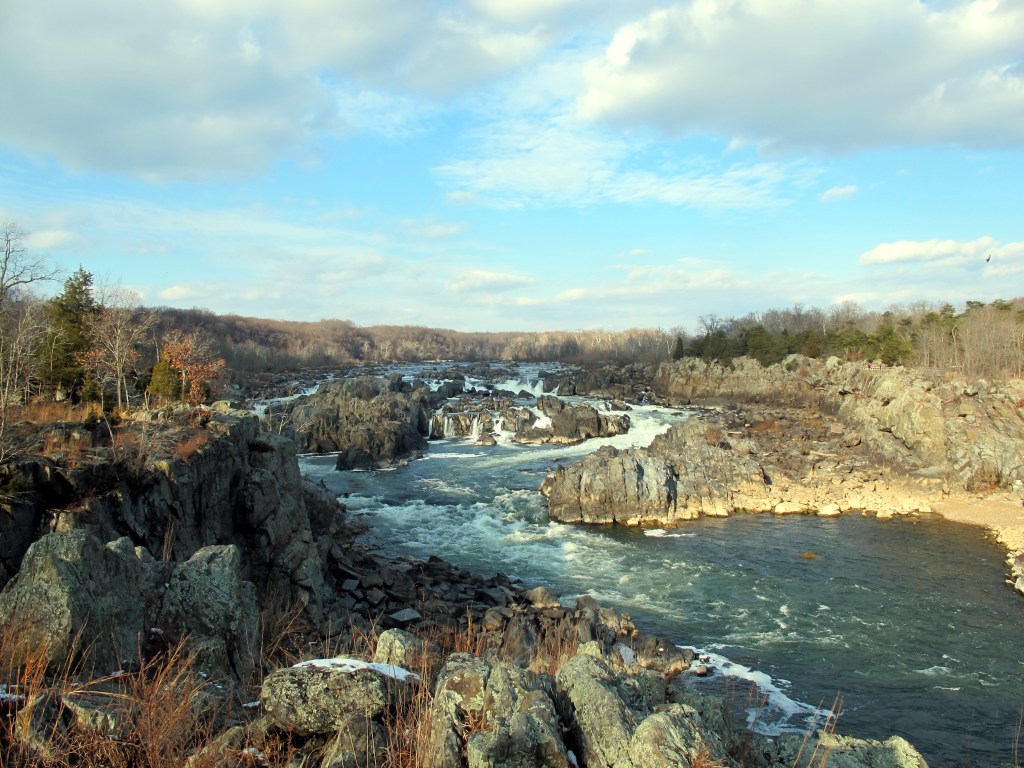
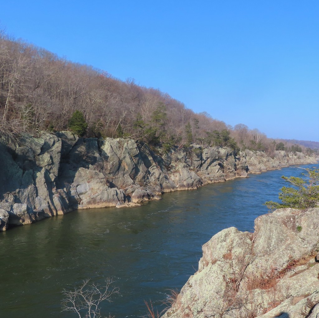
The fall line marking the Paleozoic igneous and metamorphic rocks of the Appalachian Piedmont that is the eastern edge of the North American plate is not really a line. The buildup of sediments flowing seaward to form the Mesozoic and Tertiary sedimentary rocks of the Coastal Plain is uneven and irregular, even if inexorable. The falling water gradually moves inland according to flow that varies in both time and place. The original Potomac River fall line was at Theodore Roosevelt Island just downstream from Georgetown. It first appeared about seven million years ago when the Atlantic Ocean subsided from the region. For the first five million years, the Potomac River slowly eroded the bedrock due to the gentle gradient of the run-off. The climate changed about two million years ago due to variables in orbital geometry such that the Earth was more distant from the Sun (according to the Milankovitch theory changes in eccentricity or roundness, obliquity or tilt, and precession affect the amount of sunlight reaching the earth). The four major ice ages of the Pleistocene Epoch sequestered water in ice caps and glaciers that resulted in lower ocean levels and an increase in the vertical drop and water flow erosion. Consequently, the location of the fall line moved inland at the rate of a half inch per year to Great Falls fourteen miles upstream where it is now situated. The erosional progression of flowing water follows the path of least resistance. The original Potomac riverbed on the Virginia side of the river shifted eastward toward Maryland to flow down a less resistant fault line at some point in the last million years. A fault is an area where a fracture has formed due to the opposing movements of two adjacent rock formations. The result is the canyon called the Mather Gorge with the cliffs of the fault on either side exposed by the water that removed the loose aggregate between them. There are some eight miles of the hard rock yet to be eroded until the softer deposits of upstream sediments are reached ― in one million years the falls won’t be great, only a shallow rapid. [10]
The rock formations at Great Falls and the shoreline trails along both the Maryland and Virginia sides of the Potomac basin are the Rosetta Stone of its beleaguered geologic past. At the simplest level, rock types fall into three categories according to their origin. Sedimentary rocks are deposited into oceans by rivers as sediment, igneous rocks originate from the molten lava of the mantle, and metamorphic rocks are sedimentary or igneous rocks that have been folded and twisted by pressure and temperature. The geology of the Great Falls basin is mostly metamorphic with an occasional igneous seam of granite called a dike that was intruded during intermittent volcanism; there are no sedimentary rocks. The transformed rocks that form a wide expanse from Virginia to Pennsylvania comprise the Wissahickon Formation, consisting of two main types of metamorphic rock: graywacke and schist. Graywacke, German for “gray, earthy rock,” is an appropriate euphemism for what is dull, monotonous, and virtually devoid of color or texture. Its origins are equally mundane as mudstone that accumulated in sedimentary layers as runoff into a shallow sea. Schist, which is Greek for “split” is the companion to graywacke in both origination and placement. After the graywacke mud thought to have been caused by undersea “avalanches” settled to the bottom of the Iapetus Ocean around 650 million years ago, sand deposits formed in layers on top of it. This is the origin of mica schist, sandstone transformed by heat and pressure into mica and quartzite. These rocks typically retain the striations of the original bedding and can therefore be split (schist) into layers like shale. Granitic rocks that are lighter in color penetrate the graywacke and schist in seams called dikes without regard to the twists of metamorphism indicating that they were inserted or intruded into these formations later. Radiometric dating of the granite establishes a datum of its formation 470 million years ago. The mica schist has pockets of andalusite, a metamorphic mineral (which differs from a rock in having a single chemical formula ― in this case Al2SiO5) which provides quantitative detail of the metamorphic conditions of its origin. Laboratory testing demonstrates that this mineral forms at temperatures of 650 ֩C and 5.5 kilobars which occur at a depth of 25 kilometers, or 15 miles underground. Deciphering the hieroglyphics of the rock formations at Great Falls tells the story that unfolded in its Pangaean assembly. Mud and sand sediments that collected in the proto-Atlantic Ocean were first compressed by succeeding layers and then twisted and bent by the vice of colliding tectonic plates. The flow of lava incident to orogeny ensued forming granitic intrusions. Everything came to a grinding halt when Pangaea was fully formed, leaving the relict as evidence when the ocean again parted. [11]

On September 30, 1861, the Union army’s 71st Pennsylvania Regiment camped near Great Falls in Maryland where Private McCleary (or possibly Carey) took note of the quartzite rock outcrops that he saw there. Based on his perception that the rock type and disposition were characteristics of gold deposits, he formed a prospecting group after the war that purchased the property from a local farmer and sank a 100-foot exploratory shaft into the underlying bedrock. After arduous hard rock digging for several years that produced only eleven ounces of gold, the Maryland mine project was abandoned. In 1900, the Maryland Gold Mining Company obtained the property and tunneled extensively until 1908 with similar limited success; several years later a second mine site several miles west into what was called the Ford vein was established and prospected extensively. The final gold rush followed the increase in the price of gold to $35 an ounce in 1934 when a new Maryland Mining Company was formed, extracting 6,000 tons of ore yielding 2,500 ounces of gold before the final shutdown in 1940. Over the seventy years of operation, the total amount of gold produced from Maryland gold mines was 5,000 ounces with a market value of $150,000 … that amount of gold is now worth $9M. The geologic origin of the seams of gold in quartzite veins is speculative in timing but settled in sequence. Quartzite is metamorphosed sandstone that entered preexisting fault cracks in the original rock formations as a hot solution with a variety of minerals entrained with occasional flakes of gold. The anastomosing or interconnecting veins range in size from a few inches up to twenty feet that extend in a belt roughly one quarter mile in width. In addition to elemental gold, iron sulfide or pyrite (also called fool’s gold) and lead sulfide or galena are the primary minerals. The cracks were formed long after the deposition and uplift of the graywacke and shist, probably during the Triassic Period 200 million years ago based on the existence of fissures in known and dated Triassic rocks in the general region. The faulting and hot solution sand insertion was the result of a final stage of uplift in the formation of Pangaea.[12] It took humans only a few years to dig out what nature had painstakingly assembled over eons. And all that for less than a ton of the entrancing metal called gold.
References:
1. Lustig, L. K. “Waterfalls” Encyclopedia Britannica, William and Helen Benton Publisher, Chicago, Illinois, 1974, Volume 19, pp 638-643
2. Brugger, R. Maryland, A Middle Temperament, Johns Hopkins University Press, Baltimore, Maryland, 1988, pp. 63-70.
3. Patapsco Valley Heritage Greenway, Inc., “History/Culture” https://web.archive.org/web/20100310084026/http://www.patapscoheritagegreenway.org/history/HistPersp.html
4. Hulbert, A. George Washington and the West: Being George Washington’s Diary of September 1784, The New York Century Company, 1905
5. Pickell, J. A New Chapter in the Early Life of Washington with the Narrative History of the Potomac Company, D. Appleton and Company, New York, 1856. pp. 25-50.
6. https://www.mountvernon.org/george-washington/the-potomac-company/
7. Cazeau, C, Hatcher, R., and Siemankowski, F; Physical Geology, Principles, Processes, and Problems, Harper and Row, New York, 1976, pp 374-393.
8. Romano, M. and Cifelli, R. “100 years of continental drift,” Science, Volume 350, Issue 6263, 20 November 2015.
9. Schmidt, M. Maryland’s Geology, Schiffer Publishing, Atglen, PA, 2010, pp 88-112.
10. http://www.virginiaplaces.org/regions/fallshape.html
11. Reed, J., Sigafoos, R., and Fisher J. River and the Rocks, The Geologic Story of the Great Falls and the Potomac River Gorge Geological Survey Bulletin 1471, United States Government Printing Office, Washington DC 1980.
12. Reed, J. Gold Veins near Great Falls, Maryland, Geological Survey Bulletin 1286, United States Government Printing Office, Washington, DC, 1969.
